Scaling the Rocky Nest: Mt. Hapunang Banoi and Mt. Pamitinan
Our excursions to climb mountains in the past years has often brought us to far flung provinces just to be able to satisfy our itchy legs. Never had we considered that what we are searching for is just a stone's throw away (well, from a giant's perspective) from one of us where the vista of mountains is a daily experience.
Aptly named for the myriad of mountains that surround it, our feet brought us to the mountains of Montalban. And what a thrill it was.
The Mountains of Montalban
We came across the several mountains of Rodriguez (formerly Montalban, though locals would still commonly refer to the town by this name), Rizal from several blogs and the abundance of the mountains that can be scaled piqued our interest. The town name is a dead giveaway of what to expect—Montalban comes from the Spanish monte albano, white mountain, which may refer to the several hills and mountains surrounding the area. For our journey we first thought that we might be able to complete a yet another trilogy hike, composed of Mt. Hapunang Banoi, Mt. Pamitinan, and Mt. Binicayan. When the day came, we opted for just the first two mountains as our guide suggested. We don't have to rush things anyway, do we?
I would say experienced climbers would not have a hard time scaling the two peaks. Mt. Hapunang Banoi stands at 517+ meters above sea level (MASL) while Mt. Pamitinan rises at 426+ MASL. Though not that high, the peaks offer trails that can give a good challenge.
Commuting to Rodriguez, Rizal
As always, our trip began at dawn of November 28. We met up at around 4:30 in morning at the UV Express terminal beside Farmer's Market in Cubao, Quezon City. At the terminal, we boarded the UV's bound for Montalban (not the San Mateo ones, which is just halfway to Montalban). Fare costs Php 50 each. It might take a while before the UV gets filled up with passengers. In our case, we left just before 5:00 am. The travel to Montalban took us around 40 minutes before we dropped off near Luver's Mall/Puregold San Rafael. From there, there are green tricycles marked WAWTODA that would take us to the jump off point for Php 75. At late November and being at the foot of the mountains, we were met by a chilly breeze during the 10 minute tricycle ride. We finally reach Sitio Wawa at 5:48 am.
The barangay is already lively at this time, and the breeze still feels cold as if we were suddenly transported to Baguio City. The mountains loom over us and there is a sense of awe upon seeing them.
A few days before, we are able to contact one of the guides, Jerry Zata, who is apparently the local tour guide association president, and we quickly met up with him. He guided us through the registration steps. Registration costs Php 20.00 per person while the DENR fee is Php 50.00. The tour guide fee costs Php 500 per mountain. As mentioned, we initially thought to do a trilogy hike but Kuya Jerry cautioned us on that. Apparently, Mt. Binicayan is the hardest of the three mountains and some climbers would call it a day at Mt. Binicayan, passing on on the other two peaks. We accepted his advice and proceeded with just Mt. Hapunang Banoi and Mt. Pamitinan.
All registration matters settled, we began our hike at a few minutes past six in the morning.
The Twin Hike
Our journey started with us traversing a river over a hanging bridge.The river is in fact Marikina River whose waters originate in the mountains of Sierra Madre, which includes the mountains of Montalban. Wawa Dam lies farther ahead.
 |
| Marikina River starts from the mountains of Montalban |
The whole trail is part of the larger Pamitinan Protected Landscape which is managed by the Department of Environment and Natural Resources (DENR). From the bridge, we already have a glimpse of what we are aiming for.
 |
| Mt. Hapunang Banoi and Mt. Pamitinan at a distance |
Legends mention of the giant Bernardo Carpio trapped between the two rocky mountains, causing earthquakes as he tries to break free.
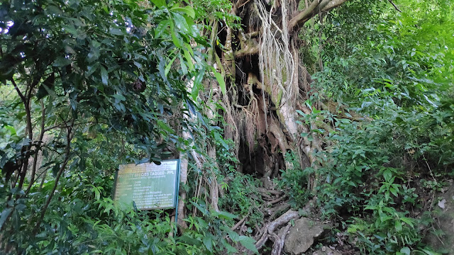
We then entered an area of short ascent where we are greeted by a balete tree and several markers indicating that we are inside the protected area.
So far, our walks had been at a leisurely pace. We passed by a wall of rock which Kuya Jerry says would sometimes be used by wall climbers and indeed, I do recall seeing some anchors on the rocks. The rocks are actually whitish which reminds me of the origin of the name Montalban.
At around 7:00 am, we landed on a junction where a store also functions as a resting area. Here we had our breakfast—some homemade salted egg lava pao made the day before. It didn't take long before a dog appeared in front of us.
From here on, the path forks into two trails, one for each mountain. Kuya Jerry said that we will first go to Mt. Hapunang Banoi then back to this junction going to Mt. Pamitinan, and finally back again here as we descend back to the jump off.
Having filled our stomach, we then started for Mt. Hapunang Banoi.
Mt. Hapunang Banoi
The path finally became thicker as we entered the more forested part. The protected area protects not just the trees from logging but the wildlife as well. Hapunang Banoi translates to eagles's nest. It goes without saying that we were expecting to see some eagles soar above our heads as we make our way up.
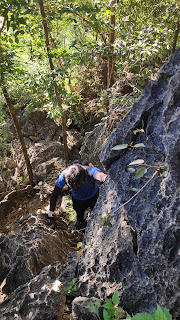
The challenge began as the rocks started to appear on our path. First we had to scale the boulders with Kuya Jerry guiding us every now on then on where to step our foot.
The rocks, most probably limestones, then turned jagged and sharp. This is my first time climbing this kind of terrain so I did my best to hang on the rocks for dear life. Thankfully, the rocks are hard and stable enough to handle our weights as we grab them as we climb up. While the rocks may not be razor sharp, they are still jagged enough to bruise you if you're not careful.
Finally we emerged into some sort of bamboo grove which means we are near the top.
The rocky trail still continues though. Finally at around 8:30 we finally reached the rocky summit of Mt. Hapunang Banoi.
 |
| At the summit of Mt. Hapunang Banoi |
You can see more of the Sierra Madre range here. The Marikina River winds farther up into the mountains while city scape seems tiny at the distance. We lingered for a short while as we soak up the scenery.
Going back the same way (and with the same challenges) we arrive back at the junction for a brief rest. From there we can hear people from Mt. Pamitinan since more climbers had arrived as the day continues.
Mt. Pamitinan
It was around 10:00 when we started our trek to Mt. Pamitinan. The trails is similar to the one going up Hapunang Banoi though I'd say the the rocky ascent begins immediately at Pamitinan. As we go up, Kuya Jerry has also been kind enough to take a lot of pictures of us.
Finally at close to 11:30 and the sun high above us, we finally reached the summit of Mt. Pamitinan.
 |
| At the summit of Mt. Pamitinan |
The summit of Mt. Pamitinan has some shade to shield us from the noon sun. It was at this point that high above did we finally sea the sillhoutte of a big bird. Kuya Jerry says it is a falcon but whatever it is, we're glad to have seen a raptor while climbing the eagle's nest.
 |
| A raptor as seen from the summit |
I'd say it is a great experience all together, a combination of thrill and awe. We started our descent more carefully than before since we are still passing by the same sharp rocks. It was one in the afternoon when we finally reached the same hanging bridge from earlier.
 |
| Montalban gorge |
Wrapping Up
Having settled all affairs at the registration area, we bid farewell to Sitio Wawa though I guess it wouldn't take long before we come back again to try and conquer the rest of the peaks and fulfill our wanderlust.
But at that moment, having went atop and back again there is finally another hunger that mere lava paos cannot fulfill 😋.


Comments
Post a Comment