The Trail of the Grasses: Mt. Tagapo (a.k.a Mt. Susong Dalaga)
2 October 2022. The weather outlook from the past week was that it would be a clear weekend. We rose up early on a Sunday morning to a light drizzle. I was hoping that we would not have to sink our climbing shoes on muddy terrain but I guess we have to endure another day that way.
We started out our trip at 3:30 in the morning. Luckily we had private transport courtesy of our friend and after collecting each one of us from our respective homes, we were on our way to Binangonan in the province of Rizal. Our destination, Talim Island and its highest point, Mt. Tagapo.
Talim Island and Mt. Tagapo
Situated at the center of Laguna de Bay, Mt. Tagapo rises on Talim Island. The mountain is divided between the municipalities of Binangonan and Cardona, both in Rizal province. Towering at a modest 438 meters (1437 feet) above sea level, Mt. Tagapo is also known as Susong Dalaga or maiden breast due to its shape. It is said that the mountain gets its name from the word taga, which means "to chop".Travelling to Binangonan, Rizal
 |
| St. Ursula Parish Church |
At our speed, it took us roughly 2 hours to reach Binangonan Port. We had a hard time finding a spot to park our car, what with a busy Sunday morning and all. We even tried to park it in front of St. Ursula Parish Church but we were told by a staff member that it is not possible. Any other day would have been fine, according to him, but it is a Sunday and many parishioners would need parking space and we would be away for quite a while.
 |
Map of Talim Island |
After some time going around and asking some locals, we chanced upon a parking area close by the port. Though the place itself was full, the staff had been accommodating enough to allow us to park in front of other vehicles as long as we leave the key behind so they can move the car if it would be necessary. Think valet parking, but with very big trust to the valet. Parking costs 50 pesos for the whole duration of our journey. There was a brief downpour while we were parking and we had to wait for it to lighten up before we headed for Binangonan Port.
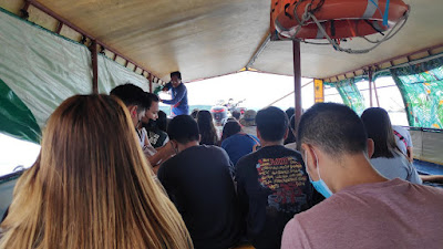
We had to cross Laguna de Bay on a boat to reach Talim Island. I was expecting one of the small boats that we can charter but it was actually a wide covered passenger boat with benches inside. It took a while for the boat to be filled up and only then did we leave the port. It was already 7:40 in the morning. Thankfully, the weather cleared up and we transited under the warm morning sun.
The boat ride took almost an hour and cost 50 pesos per passenger. Laguna de Bay is a large lake and the ride reminded me of the island hopping tours we had before. We passed by several fish pens and islands of water lilies before stopping at a couple of barangay stations.
 |
| On board the boat to Talim Island |
 |
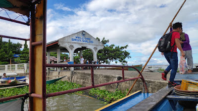
| Barangay Janosa station |
 |
| Barangay Gulod station |
The jump off point of the Mt. Tagapo trail is the newly-built tourism office in Barangay Gulod. We learned that the jump off point has been transferred there since March 2022. We filled up the registration form and each of us paid a 50 pesos fee, which also included the environmental fee. Our blood pressures have been checked as well as part of their protocol. There is a bit of inclined walk from the port to the tourism office so a quick rest would be advisable prior to the BP measurement. We were introduced to Mang Andong who will be our guide during our trek to the summit and back. The fee for the guide for every 5 persons is 500 pesos but with the 6 of us, we paid 600 pesos. We were told the trek to the summit would take us one to two hours. It was already 9:00 when we began our ascent.
Climbing Mt. Tagapo
For a fit person, even for a beginner, the trail up the mountain is not a difficult one. We first passed through some residential areas on a paved road before being flanked on both sides by bamboo trees.The path then transforms to a rocky one and appears to be a dried up river with small puddles every now and then.
You could hear the sound of a small stream on the side of the path before reaching the part with a bit of an assault. It seems like the path has not been used for a while, if not sparingly, over the past weeks since we passed by very thick vegetation and Mang Andong would continue chopping his way ahead. He even made a couple of walking sticks for us to help some of us with the hike since some portion of the path was slippery.
It is highly advisable to wear long pants and sleeves as the trail is full of tall grasses, even taller than a person, and brushing with them is unavoidable. We would stop a few times along the way to fill ourselves up and get comfort from the cold breeze. Once we emerged from the tall grasses, we were greeted with a spectacular, wallpaper-worthy view from the final stop before the peak.
 |
| Blissful view of the mountain |
After a quick stop on one of the huts at this part, we made our final push to the top of the mountain, again going past tall grasses...
before finally reaching the summit of Mt. Tagapo.
The summit offers a 360 degrees view of Laguna de Bay. Over the horizon, we can see a number of mountains including Mt. Makiling in Laguna, Mt. Banahaw in Quezon, and Mt. Sembrano in Pililia, Rizal which we climbed a week earlier. The view here is definitely better than the one we have seen from Mt. Sembrano. Our ascent took us over 3 hours but again, not everyone in the group is a seasoned climber, but I can confidently say that it can be climbed in just a couple of hours.
A few minutes of photo ops and resting done, we finally began our descent, going back the same path. Going down was quicker but we also had to hurry up because we had to catch up to the last boat schedule which is 3:00 in the afternoon. Fortunately, another guide was able to contact the next station and told them to pick us up. We also had enough time to buy some souvenirs in the tourist office where they have a selection of T-shirts featuring the mountain for 250 pesos each.
The ride back to Binangonan Port took us longer than before because the boat had stopped over almost all barangay stations to pick passengers up, as opposed to just the two barangays earlier. Seeing the mountain that we climbed earlier as it towers Talim Island made us feel proud of ourselves.
The summit offers a 360 degrees view of Laguna de Bay. Over the horizon, we can see a number of mountains including Mt. Makiling in Laguna, Mt. Banahaw in Quezon, and Mt. Sembrano in Pililia, Rizal which we climbed a week earlier. The view here is definitely better than the one we have seen from Mt. Sembrano. Our ascent took us over 3 hours but again, not everyone in the group is a seasoned climber, but I can confidently say that it can be climbed in just a couple of hours.
 |
| The land jutting on the left is Jalajala, Rizal. The mountains on the horizon are in Laguna and Quezon. |
Wrapping Up
 |
| The tourist office offers a selection of souvenir T-shirts and mugs |
The ride back to Binangonan Port took us longer than before because the boat had stopped over almost all barangay stations to pick passengers up, as opposed to just the two barangays earlier. Seeing the mountain that we climbed earlier as it towers Talim Island made us feel proud of ourselves.
Fortunately, our car was still where we left it. Before heading home, we had our hard-earned dinner at Hiraya Restaurant in nearby Angono, Rizal.


Comments
Post a Comment